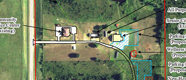
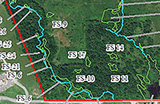
A report prepared for agency approval cannot occur without detailed and accurate mapping. EEC has the experience to prepare mapping products that provide our clients with a complete understanding of our projects. A well-prepared map is designed to organize and present project related details in an accurate and aesthetically pleasing fashion. EEC can present a various array of environmental information onto a map or map set that provides our clients with consistently formatted and balanced mapping products.
EEC successfully uses GIS mapping to:
GIS Analysis: Utilizes GIS and CAD technology to graphically analyze and display environmental features in support of biological and ecological services including environmental impact assessments, National Environmental Policy Act (NEPA) documentation, endangered species, fish and wildlife habitat, wetland and waterway delineations, noise impacts, soil distribution and hazardous material locations.
- Develop alternatives to facilitate agency reviews and approvals
- Develop and maintain program specific geographic information system (GIS) data layers from vector sources
- Research, analyze, and incorporate All Source data, maintaining elements of the GIS database, including source metadata.
- Produce standardized and custom maps for environmental report documents.
- Conduct Geospatial analysis to prepare recommendations for actions.
Our GIS experts have the experience to extract environmental data from multiple sources to provide:
- Accurate and Rapid Data Collection
- Wetland, Riparian Areas, Wildlife Habitat, Prairie Restoration Area Location
- Detailed Positioning
- As-built Drawings and Schematics
- Feature Layout and Mapping
- Visual Project and Progress Presentations
- Site Plan Analysis
- Graphical Interface with Multiple Project Components
- Database Management
GIS and Mapping


Offices in:
Vinita, OK 918 272 7656
Ft. Smith, AR 918 244 9595

Contact
Home
NEPA Documentation
Environmental
Site
Assessments
Threatened & Endangered Species
GIS Mapping
Waters of The United States
Mitigation & Monitoring
Complete Service
Listing
Traffic Noise Assessment
& Barrier Analysis
Cultural Resources (Archeology)
Eagle Environmental Consulting, Inc. | Vinita, OK (918) 272-7656 | Ft. Smith, AR (918) 244-9595
All Material © Copyright 2018 by Eagle Environmental Consulting, Inc.
Website Design, Layout and UX by Babcock Illustration & Design